EUROPEAN
VACATION

The Netherlands
Amsterdam
- received July 28
After 28
hours of traveling (17 hour ferry ride and 11 hours of driving) we arrived in
the big bad city of Amsterdam.
I have only heard of the liberal life style and the freedom of drug use and
prostitution. I was a little nervous bringing the kids to this place especially
after just seeing that lifestyle in Oslo,
Norway.
We took the
# 4 cable car into the city and got off at Central Station, and it was really
expensive. For the 4 of us to go about 3 miles it cost about $15 bucks
American.
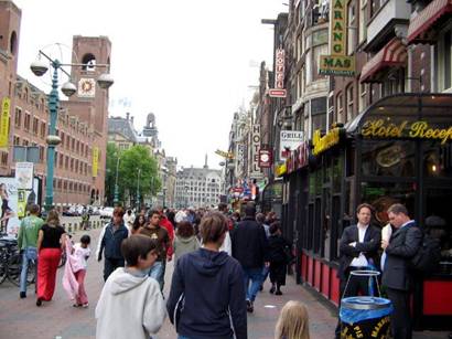
At first
glance it looked just like any other big city, jammed packed with tourists. We
did not see any of the dark side, but you could smell pot in the air on every
other block. We walked through the city and found an Ozzie pub restaurant place
to eat. We had wings, nachos and ribs, and it was O.K. but we were distracted
every once and while by a poor gent who was suffering from some mental issues
and would yell at us while we ate.
Nikolas was a little nervous because he was worried the guy was going
to come over and rough us up, but he would move on and yell at someone else. It
was not that bad, just freaked Nik out.
So that was dinner, and after that we walked
the streets and tried to see some of the beautiful architecture and soak up
some culture.
Amsterdam has been an important center of
European cultural life since the 17th century. The city is the site of the
National Academy of Art, the Royal Netherlands Academy of Sciences, and the University of Amsterdam (1632). Its Rijksmuseum
contains one of the largest collections of Dutch and Flemish paintings in the
world, and its Stedelijk Museum
has an extensive collection of modern works. The Van Gogh Museum
includes about 800 works by 19th-century painter Vincent van Gogh in its
collection. Amsterdam
is also noted as the home of the renowned 17th-century painter Rembrandt; his
home is now a museum. The Concert-gebouw, completed
in 1883, is the home of Amsterdam's
renowned orchestra. The city has numerous examples of 16th- and 17th-century
architecture, as well as two historic churches: Oude Kerk (Old Church), built about 1300,
and Nieuwe Kerk (New Church),
built in the 15th century. The royal palace, originally built in the 17th
century as the town hall, stands on a large square in the center of the city
and seems to be the tourists hang out.
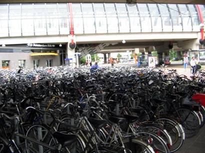
One off a million bike
racks in Holland
The whole
city was under construction, I mean every street was ripped up and there was
this huge back hoe tearing a huge hole into the ground. It made it very
difficult to enjoy the city, but we did. We really liked the place, it had so
many canals running through every block with little house boats resting along
the shore.
I would not
hesitate to come back here or advise anyone else to come here. It is a young
back-packer’s paradise, with so many options for lodging and tons of other
young back-packers from all over the world.
Our next
stop is Belgium and then
back to London.
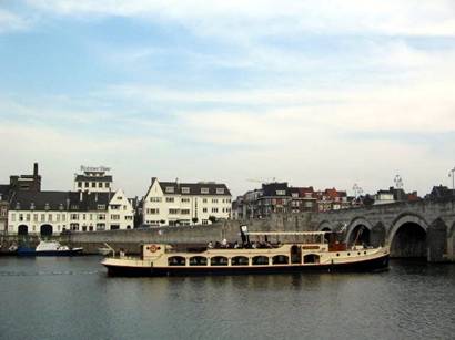
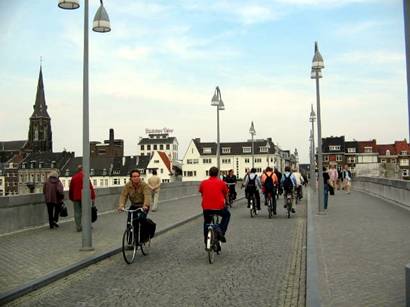
Maastricht - received June 2
The only
place in the world that has more bicycles than people, I am not kidding. I
thought Belgium
had a whack, but it says here in the book that The Netherlands has more
bicycles than it does people. We stayed in one of the countries most beautiful
cities called Maatricht. Our hotel was right on the
river and we could easily walk through town and do our usual. Churches, eat,
eat, and coffee. We did not do a canal tour because this was a major shipping
river with barges running up and down every 5 minutes so it was not as romantic
as Gent or Brugge
Netherlands,
The, also known unofficially as Holland, constitutional monarchy of
northwestern Europe, bordered on the north and west by the North Sea, on the
east by Germany, and on the south by Belgium. With Belgium
and Luxembourg, The
Netherlands forms the Low, or Benelux,
Countries. The Netherlands Antilles and Aruba, islands in the Caribbean,
are part of The Netherlands. The European portion of The Netherlands has a
total area of 41,526 sq km (16,033 sq mi), of which 33,939 sq km (13,104 sq mi)
is land surface. The country’s capital and largest city is Amsterdam.
In the late
16th century a Dutch revolt against the authority of the king of Spain, at the time ruler of what now constitutes
the Low Countries, succeeded in the northern
provinces, which later became the Netherlands. The Dutch Republic,
officially established in 1648, fell in 1795 when the armies of Revolutionary
France imposed a pro-French government. In 1810, France
annexed the Netherlands, but
with the defeat of Napoleon in 1814 to 1815, the present Dutch state,
officially called the Kingdom of the Netherlands, came into being.
Originally Belgium
was part of this new kingdom, but it seceded in 1830 and formed an independent
country. The present boundaries of The Netherlands are essentially those
established after the secession of Belgium,
although they are similar to the borders of the Dutch Republic.
About half of the country’s landmass lies below sea level.
The Netherlands, as
its name suggests, is a low-lying country. About half of the country’s landmass
lies below sea level. This amount would increase should the polar ice caps melt
and slowly raise the level of the sea due to global warming. Much of the
western part, situated below sea level, is covered with clay and peat soils
interspersed with canals, rivers, and arms of the sea. Farther to the east the
land lies slightly above sea level and is flat to gently rolling. The elevation
rarely exceeds 50 m (160 ft). Most of the land is devoted to agriculture; only
small areas of forest and heath remain.
Windmills,
The Netherlands For centuries the Dutch relied on windmills for energy
production and had built about 9000 of them by the 19th century. Traditional
windmills, such as these in the countryside near Amsterdam,
can be seen all over the Netherlands,
and many are still in use. The country’s mostly low-lying terrain has few
topographical features to impede the wind that operates the mills.Photo
Researchers, Inc./Tony Craddock
The North Sea coastline of The Netherlands consists mostly of
dunes. In the southwest are gaps in the dunes formed by river mouths, creating
a delta of islands and waterways. In the north, the dunes were broken through
by the sea, thereby creating the West Frisian Islands and behind them a tidal
sea called the Waddenzee.
Adjacent to the narrow strip of dunes is an area lying below sea level that is
protected by dikes and kept dry by continuous mechanical pumping. The former Zuider Zee, a large arm of the
sea, is being reclaimed. A dike separating it from the sea was completed in
1932, when work was begun to drain about 225,000 hectares (about 556,000 acres)
to form reclaimed land known as polders, such as Flevoland
and the Northeast Polder. About three-quarters of the area had been reclaimed
by the early 1980s. The remaining freshwater lake is called the IJsselmeer.
On February 1,
1953, the spring tide severely flooded the delta region in the southwest and
about 1,800 people died. The Delta Plan, launched in 1958 and completed in
1986, was implemented to prevent such flooding. Under the plan, the Dutch
shortened the coastline by about 700 km (about 435 mi); developed a system of
dikes; and built dams, bridges, locks, and a major canal. The dikes created
freshwater lakes and joined some islands.
I think we
were a little pooped out when we were in Maastrict,
but we would never hesitate to come back.